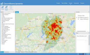
Georeferenced analyzes take into account the geographic location of objects, trying to infer an approach of distinct subgroups by their positioning and grouping in relation to their geographic coordinates. Caseboard’s georeferenced analyzes can use different types of online maps such as Google Maps, Bing and Open Maps in their map, terrain or hybrid versions, in addition, the background map can be changed at any time without loss of data or need to redo the work.
Map tools have the following characteristics:
– Import of files in the most diverse formats containing address or latitude and longitude information that will be automatically georeferenced and shown on the map.
Base Station drawing or range of radios, antennas and other devices.
Layer control.
Creation of polygons for delimitation of geographical areas such as violent areas.
Catalog with the polygons that represent all the cities of U.S.A..
Color maps for concentration analysis.
Probable routes and paths with calculation of distances between points.
Creation of marker on the map by addresses.
Allows you to save/open the maps independently for future georeferenced analysis..